When it comes to lake management, the only way to ensure the best results is to have the best information possible about the lake you are trying to manage. Often, pond owners find themselves needing to make guesses about the state of their pond and this can often lead to inefficient or even ineffective management. To design strategic practices for lake management that achieve your dreams as efficiently as possible, you need to start by gathering data about your pond’s current state.
Our specialists are equipped with the technology and skills required to gather valuable data about your lake’s topographical features, developing maps detailing habitat presence, earthen features, siltation, and contours. With this information, management decisions can be made with your pond’s specific features in mind, ensuring that your management plan is designed with your lake’s unique features and needs in mind.
We offer different types of mapping services depending on the intended use for the maps as well as the desired level of precision:
Recreational Mapping
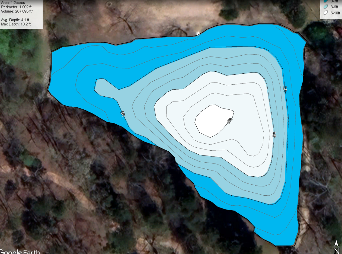
Our trained technicians will operate a boat equipped with sonar units capable of measuring the depth of your pond. Using this equipment, they will survey the entire pond, collecting data on the depth and features present at the bottom. This data can then be compiled into an easy-to-read map partnered with a personalized report that details the findings.
This service is useful in determining where additional habitat may be beneficial as well as guiding decisions for installation of bottom diffused aeration systems, application of water treatments, and even fishing hotspots and habitat placement! Knowing the topography of your pond allows you to make the most informs management decisions that make the most of your investment and guide decision making, taking the guesswork out of many aspects of pond management.
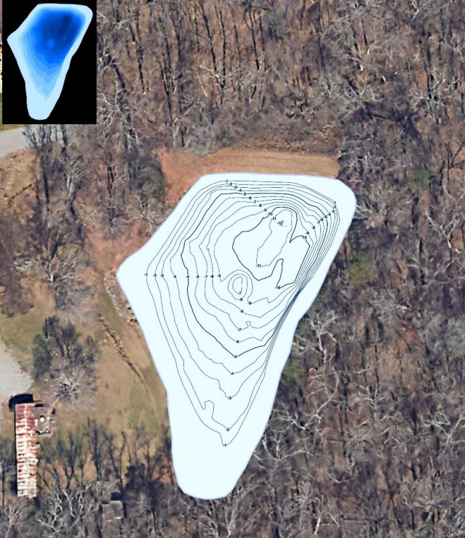
Professional Grade Mapping & Sedimentation Survey
Are you considering whether your pond will need to be dredged? This is often one of the most daunting decisions that any lake owner needs to make. Between the possible impacts on your fishery to the high cost of dredging an entire lake, it is crucial that you have all the information necessary to decide which services your lake actually needs. Such a large endeavor is far from the time for guessing what services you need.
With our partnership with The Mapping Network and our team of qualified technicians, we are here to help take the guesswork out of this process, providing hydrographic surveys that comply with International Hydrographic Organization (IHO) standards and US Army Corps of Engineer Hydrographic Surveying Manual EM1110-2-1003 standards. Our quality assurance and quality control (QA/QC) procedures meet or exceed local, state, federal and country requirements.
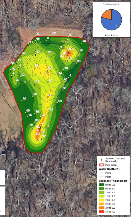
With a sediment survey, we measure, model, and describe the physical features of water bodies as well as predict change over time. Reservoir sedimentation is a complex process that varies within each watershed. It reduces water volume capacity for flood control, drinking water storage, recreation, power generation uses, etc. Sedimentation also has dramatic effects on the ecology, recreation and aquatic vegetation.
Our professional grade mapping and sedimentation services include:
- Peace of Mind in Dredging Decisions: With high quality information and reporting on the areas where sediment is accumulating, you can be sure that you are spending your financial resources on the right issues, making the most of this investment in your lake topography.
- High Quality Reporting: The reports that we design after a professional grade mapping service are uniquely designed around your vision and goals for the lake, with recommendations that align with the concerns you have expressed. These detailed maps can be used for many of the same decisions as the recreational maps, with far greater accuracy and detail.
- Professional Documentation: These maps are highly accurate in their depiction of sedimentation and can provide important insight in the event of heavy sedimentation events. Whether the sediment originates from construction nearby, or heavy erosion into your watershed, our professional sedimentation surveys can map the buildup of sediment in your lake with great precision.